
18th September 2018
Event phone:
Abstract
The Buzzard Field: Exploration, Appraisal, Phase I Development & Beyond
Dean Gagnon, Nexen Petroleum U.K. Ltd.
The Buzzard oil field, located in the Outer Moray Firth of the North Sea, was nearly discovered twenty years earlier (Figure 1). In 1980 well 20/06-1 drilled off the southern edge of field by 1200 m (Figure 2). The Jurassic section in 20/06-1 was found to be thin and shale prone. Another near miss occurred in 1986 when well 20/06-2 intersected Upper Jurassic sands 2000 m east of the Buzzard field oil-water contact (Figure 2). Well 20/06-2 intersected 360 feet of net sand and 10 feet of net pay. Fifteen years later well 20/06-3 spudded 25th April 2001 intersected an oil bearing Buzzard Sandstone Mbr on 11th May 2001, 84 feet shallower than prognoses at -8406 feet TVDSS (Figure 2). The daily drilling report stated:
SANDSTONE (10%) Mostly seen as rock flour: Off-white – grey-white, mottled, striated, brittle, very slightly calcareous. Only traces of aggregated sandstone: Pale brown-yellow (oil stain), colourless quartz grains, moderately – poorly indurated, friable, fine, sub angular, well sorted, clean, moderate visible porosity.
OIL SHOWS: 5% pale brown-yellow oil stain on cemented grains, very bright pale greenish-yellow sample fluorescence, slow-streaming milky yellow-blue cut fluorescence (wet cuttings), no natural cut colour, invisible residual ring with bright greenish-yellow fluorescence.
24 HOUR FORECAST: POOH for 90 ft core barrel. RIH. Cut core #1.
The Buzzard prospect had a 12% chance of success; containment was the key risk with no apparent closure to the west (Figure 3). Well 20/06-3 intersected 318 feet of net sand and 269 feet of net pay with an average porosity of 20% (Figure 4). A DST flowed 6,550 stb/d of undersaturated 32°API oil with a viscosity of 1.46 cP and a gas-oil-ratio (GOR) of 271 scf/stb. A side-track, 20/06-3Z, was drilled to the east where the oil-water contact was intersected proving up a 750 foot oil column. By 2003, three semi-subs had drilled an additional 10 appraisal wells. The original-oil-in-place (OOIP) in the Buzzard development area was estimated to be between 757 and 1,224 MMstb in the Field Development Programme submitted in late 2003 to the DTI (now OGA). The current OOIP is in excess of 1,500 MMstb. Pre-production development drilling commenced in 2005. Production wells were drilled from the Buzzard Well Head Platform with the Galaxy III Jack-up rig, water injection wells were drilled from two sub-sea manifolds east of the Buzzard Installation with a number of different semi-submersible rigs. The field was brought on stream in January 2007 by operator Nexen Petroleum UK Ltd. Plateau production rates of 220,000 bopd were quickly reached, sustained by continuous development drilling and much more OOIP than originally estimated. Phase I Buzzard development drilling finished in mid-2014 with well 20/06a-B38Z and the use of all 36 slots on the Buzzard Wellhead Platform. The field came off plateau shortly afterwards at the end of 2014. By mid-2018 over 685 MMstb had been produced. To arrest production decline a second phase of development drilling has been planned. This second phase is composed of two separate drilling campaigns, ‘Infill’ and ‘Buzzard Phase II’ (‘BPII’). The Infill wells will be drilled from the Buzzard Wellhead Platform using abandoned Phase I donor wells to access targets across the southern and central portions of the field. The BPII wells will be drilled from a new sub-sea manifold located in the north-eastern area of the field using a semi-submersible drilling rig to access targets which are too distant to be drilled from the Buzzard Wellhead Platform.
Since the completion of drilling in 2014 the Asset Team has focused on the interpretation and integration of the vast static and dynamic Buzzard data set including:
- well/geological data acquired from 2001 through 2018
- innumerable third party geological, geophysical and reservoir engineering studies
- OBN baseline and 1st 4D monitor surveys
- production; water break through, water cut development, tracer detection, pressure interference data
This work underpins the well planning for the forthcoming Infill and BPII drilling programmes, as well as intervention campaigns to reduce water cut and add oil barrels, the geological/dynamic model update, and the day to day reservoir management.
This talk will start with a brief summary of the exploration and appraisal of the field. An overview of the Phase I development drilling will follow. Finally, a summary of the current geological interpretation of the field will be given including an overview of the upcoming drilling programmes.
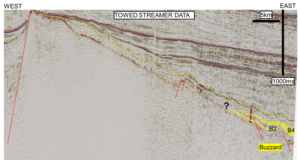
Figure 3 . Ettrick Sub-Basin Regional Seismic Line Illustrating the Key Risk of the Buzzard Prospect, up-dip containment
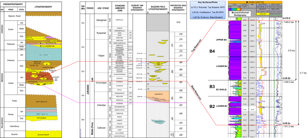
Figure 4. Nexen Regional Stratigraphy
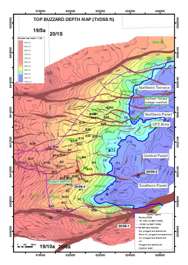
Figure 2. Buzzard Field – Top Depth Structure Map
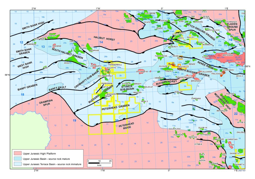
Figure 1.Buzzard Location 50 km NE from the Grampian Region of NE Scotland
About
The lecture starts at 6.30pm, with drinks available from 6pm
Venue Information
Venue information
Venue name:
Jurys Inn