
14th January 2020
Abstract
The British Geological Survey exists to give impartial, expert advice on the subsurface to the government, industry and the UK public. Yet discussion about issues like development of unconventional hydrocarbons has been hampered by the lack of comprehensive and open data available to understand the properties of the UK subsurface. Whilst we act as custodian for huge volumes of digital data and physical samples, the lack of complete and internally coherent datasets for common locations makes understanding complex issues problematic. The difficulty in accessing the data necessary to study these problems, especially when immediate responses are required by government or to reassure the general public after any kind of incidents can be a real problem.
In June 2019 after a 3 year process the British Geological Survey was given planning permission to deliver the UK Geoenergy Observatories site in Cheshire. The Cheshire Energy Research Facility Site (CERFS) has been designed to deliver brand new research capabilities it the UK’s earth science community, funded by NERC on behalf of the UKRI.
The UK faces many pressures on its environment and it need to ensure energy security in the coming years Resolving these issues and understanding and quantifying risks inherent in any use of the subsurface is critical for public understanding of these issues. These risks need to be expressed honestly and transparently to ensure that the UK public can make informed decisions about how best to decarbonised our economy.
CERFS consists of a series of arrays of different boreholes across a site that’s approximately 4 km east-west by 3 km north-south. Collectively the arrays will allow the geology of this area to be described and characterised to extremely high resolution (see Figure 1, a map of the drillsite). The site lies across a horst block with grabens either side (See Figure 2, a seismic section that highlights these structures):
Array 1 will study the groundwater in the superficial deposits and top of the underlying Permo-Triassic sandstones which are a potable water aquifer;
Array 2 will provide the UK’s highest resolution seismometer array capable for measuring earth movement as small as -0.6 to -1.0 M;
Array 3 will provide a 1200 m deep research borehole which will define the detailed stratigraphy and the Permo-Trias and Carboniferous sequences in this area;
Array 4 will allow detailed flow testing of the properties of the faults, testing of geothermal potential, and detailed testing of the hydrogeology of the overburden.
Once these wells are complete this site will provide a completely unique research infrastructure allowing hydrogeological testing for research questions, testing of new downhole equipment and sensor technologies. The completed drillsite will become the prime site for undertaking geological research and subsurface technologies in the UK.
A core component of the UK Geoenergy Observatories approach is the openness and transparency of the data to be collected. All initial data will be made available via the UK Geoenergy Observatories portal (ukgeos.ac.uk) to the scientific community as soon as possible post acquisition. Basic acquisition data will be available to anyone interested within days to weeks of collection.
Scientists will be given the opportunity to take samples of all rock, fluids and gases; they will be given up to 2 year to undertake research under a moratorium, thereafter all of the research results will be added to the portal. The intention is to create an ever growing archive of the geological data around this observatory to improve our understanding of the detailed processes in the subsurface. This will create a location and detailed database of high-resolution geological data which will allow detailed modelling to be undertaken to predict potential future uses of the subsurface.
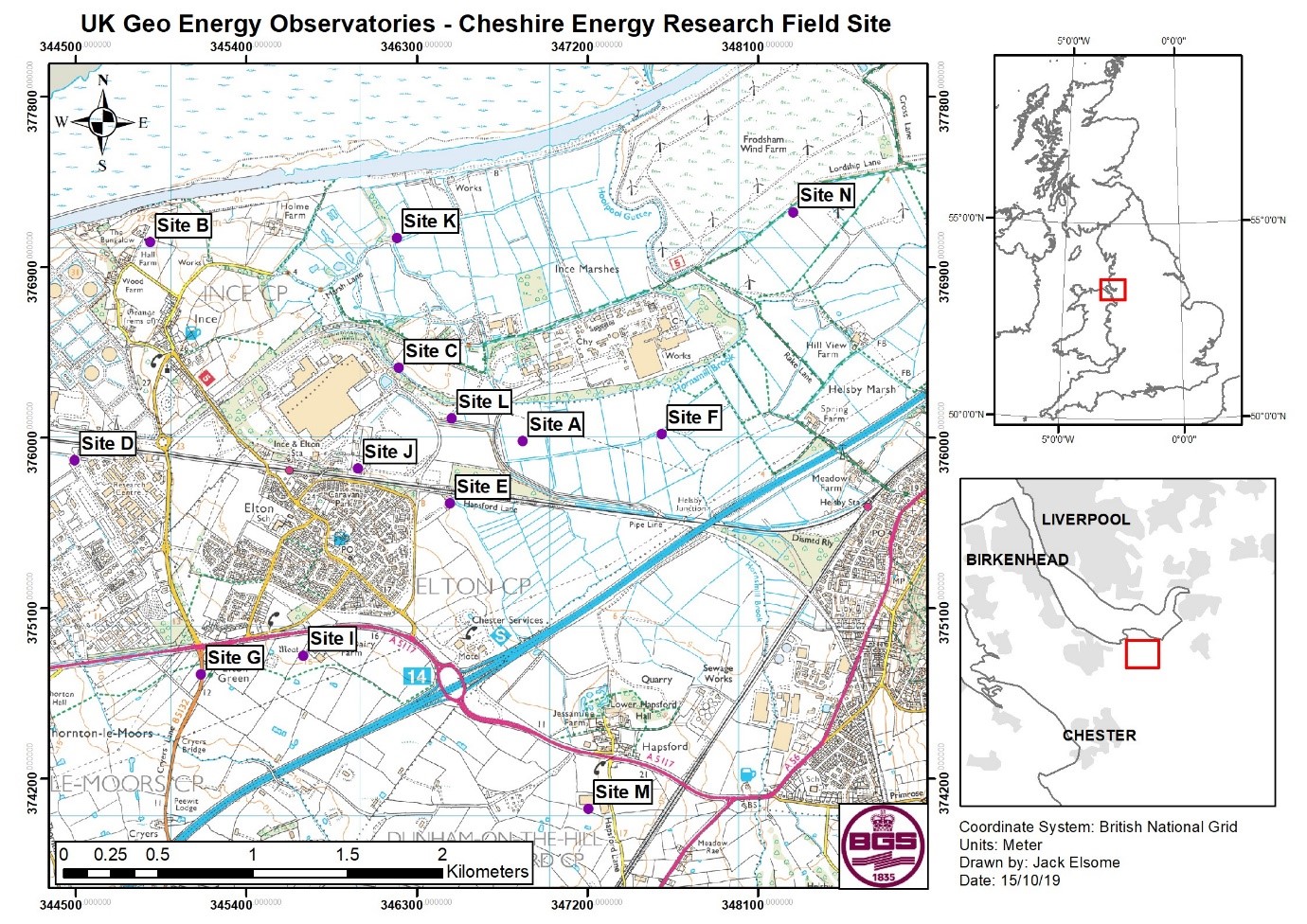
Figure 1: map of UK Geoenergy Observatories Cheshire Energy Research Field Site (CERFS) showing boreholes locations from each of the main borehole arrays. Contains Ordnance Survey data © Crown copyright and database rights. All rights reserved 2019. Ordnance Survey [100021290 EUL].
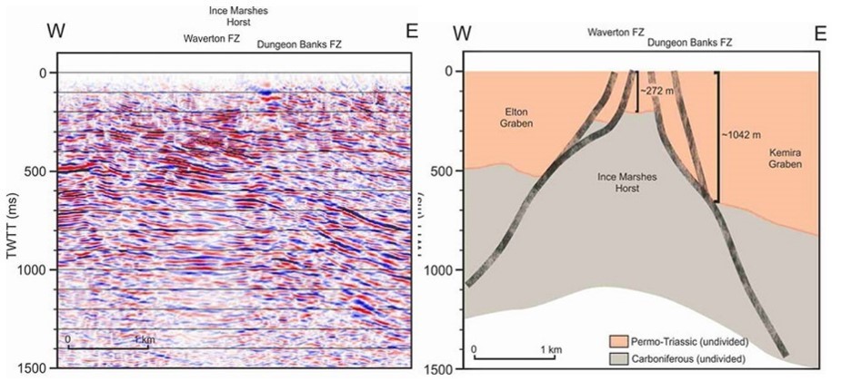
Figure 2: 2D seismic line and cartoon interpretation from across CERFS drillsites showing in the vicinity of Elton, Cheshire. Seismic data courtesy of UKOGL.
Speaker Bio
Andy Kingdon is a science team leader, petrophysicist and expert in borehole imaging with 28 years experience at the British Geological Survey. In his time in BGS he has worked on UKCS licencing rounds; site characterisation for radioactive waste disposal; run the UK programme office for Ocean Drilling Program and worked on the creation of its successors; managed the UK onshore petrophysical databases; conducted research into understanding distribution of the physical properties in the subsurface and the UK in-situ stress field amongst many other things, all without the hassle of ever having to apply for another job.
He is currently funded to research into the stress field and pathways through the overburden around potential shale gas exploration sites to understand and quantify their potential risks; research into how the subsurface can be accurately parameterised with physical properties to create better predictive models to understand the interactions between heterogeneous geology and subsurface fluid flow and the need for better data storage and analytical tools to achieve all of this. He is author of 20 peer-reviewed academic papers.
Two constants fill his CV, a belief that if the answer to the question is not “use borehole imaging” you are probably asking the wrong question, and a certainty that unless its attributed with good metadata, QAed and databased with great care under supervision of a knowledgable expert then much geological data is rendered useless so that your waste paper basket becomes your most important data management tool. His 3 year involvement in planning for UK Geoenergy Observatories is thus an attempt to make sure that we can finally have an archive of high quality, high resolution and openly available geological data, including plentiful borehole imaging, we can really rely upon to research the hard questions about how we power and heat the UK into the future.