
10th March 2020
Abstract
The offshore Gulf of Papua has a vast areal extent of over 187,000km2. It is significantly under explored with only 27 offshore exploration wells drilled, all of which are restricted to the Fly River Platform and the nearshore Aure Fold Thrust Belt areas.
The deepwater offshore Gulf has been largely ignored by industry due to paradigms around the extent of oceanic crust, presence of source and reservoir facies. An extensive regional dataset was acquired by Searcher Seismic in the Gulf be-tween 2006 and 2018. The Searcher Database includes 76,361km of 2D data, 1,795 km2 of 3D data, gulf-wide shipborne gravity and magnetics data, transition zone airborne gravity and magnetics, 75 seabed cores, 37 heat-flow observation points and five dredge samples. All these data-sets, plus a full satellite slick database from Airbus, were made available to Discover to carry out a detailed geological and geophysical review and develop a deep understanding of the hydrocarbon prospectivity of the Gulf of Papua.
Exploratory drilling to date has focused on the Fly River Platform and the Aure Fold Thrust Belt, with other areas of the gulf, including the Moresby Trough, Eastern Plateau, Offshore Papuan Plateau and the Coral Sea remaining completely unexplored. The traditional play types targeted by oil and gas companies in the Gulf of Papua to date include Miocene platform carbonates and pinnacle reefs, basement related horst blocks and Pliocene basin floor fans.
Discover carried out regional seismic facies mapping as a tool for development of paleogeography maps and numerous additional play types have been identified away from the drilled nearshore and onshore areas. Utilizing the Searcher data, we were able to image down to 35km depth and map a likely Moho depth horizon. The data also illuminates a distinctive Coral Sea oceanic crustal character which was mapped and compared to the areas of attenuated continental crust. It was found that the actual extent of the true oceanic crust is most likely much more restricted than previous publications would suggest, with most of the Gulf and Offshore Papuan Plateau areas being under-lain by attenuated continental crust. This has significant implications not only for heat flow modelling but also for the interpretation of the stratigraphy preserved between the basement and the Base Tertiary Unconformity.
Reprocessing of the PPL379 3D seismic survey has resulted in a new deeper interpretation of the basement depth which leads to interpretation of a thick section of Mesozoic fluviodeltaic to shallow marine sediments sitting below the Base Tertiary Unconformity, known to contain source rocks in the nearshore and onshore areas.
Searcher acquired the Davaria Geochemical survey in 2017. The survey utilised satellite slick interpretation over 180,000 km2 in the gulf and used that data to choose locations for the geochemical sampling. Multibeam Bathymetric Surveys were conducted to identify seafloor anomalies and potential plumes. Drop cores were collected in areas of interest. This included sampling across the offshore Papuan Plateau. In total, 75 Seabed cores, 38 Heatflow observation sites and 5 Seabed dredge samples were acquired.
The results of the heatflow sampling are consistent with the interpretation from seismic data that the bulk of the offshore, including the Offshore Papuan Plateau, is underlain by attenuated continental crust. Geochemical sampling of the drop cores indicates the presence of thermogenic hydro-carbons of similar organic compound signature to the Mesozoic derived oils discovered in the onshore Papuan Fold Belt.
An extensive 1D basin modelling study was also conducted. Results in-dicated that the interpreted Mesozoic source rocks in grabens across the Gulf of Papua began expulsion in the Early Cretaceous and suffered a hiatus during the Late Cretaceous and Tertiary uplift and erosional events, before becoming buried once again to maximum depth at present day. This modelling suggests that there is currently an active charge system throughout the grabens across the Gulf of Papua and the conclusion is supported by the seabed coring, seep and slick data and heatflow survey results.
The Gulf of Papua has been largely ignored by industry to date due to previously entrenched paradigms of thin, cold Tertiary stratigraphy over-lying oceanic crust. The results of Searcher’s Geoscience program in the Gulf of Papua all point to a prospective basin with Northwest Shelf of Australia style stratigraphy, present day hydrocarbon charge and multiple play types.
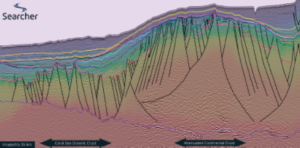
Figure 1: Deep imaging of Haere 2D Seismic survey illuminates Moho Depth
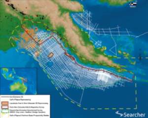
Figure 2: Map of Gulf of Papua and Seismic locations
Sponsor and Exclusive Arrangements
Hot canapés and beverages will be served during the post-lecture reception. The finish time for the March reception has been extended to 9pm to increase networking opportunities
Thank you to Searcher Seismic for supporting the March Evening Lecture and Drinks Reception
![]()
Venue Information
Venue information
Venue name:
The Geological Society, London
Venue phone:
+44 (0)20 7434 9944