
Africa Evening Lecture
Gondwana re-assembled: Challenges for making the new map and insights for exploration
Open to PESGB members and African E&P Conference delegates – 29 August 2017
You will need to register to attend this FREE event click here for more information
Colin Reeves1, Renata Schmitt2 and Jordan Phethean3
1.Earthworks bv, Delft, The Netherlands; 2. Federal University of Rio de Janiero, Brazil; 3. University of Durham, U.K.
A new geological map of re-assembled Gondwana to supersede that of De Wit et al. (1988) will be released later this year under the auspices of IGCP-628. Quantifying the geometrical effects of episodes of rifting within Africa – the core of Gondwana – in terms of plate tectonics is one of the challenges.
Perhaps the most obvious example is that the South Atlantic and the Equatorial Atlantic cannot be closed simultaneously against South America if Africa retains its present shape. Much, if not most, of the disparity is due to the Cretaceous rifting (136 to 124 Ma approximately) that spread east and north from what is now the Niger Delta into Lake Chad, continued through South Sudan as far as the Anza rift and the Lamu Delta. As a result, Northwest Africa is now rotated clockwise from its Gondwana ‘fit’ position. The fit requires tight reassembly to South America along both the east and the north coasts of Brazil and with correlation of geology and structure from Brazil into Nigeria and Cameroon. We envisage the early northward-propagating rift of the South Atlantic taking a 900 km eastward offset by way of parallel east-west faults in northern Cameroon and the Benue Trough in Nigeria acting as (pre-) transforms to the northerly rift extension into Lake Chad. Retaining reasonable amounts of rifted movement between other plates in the system NEAfrica-Arabia-Congo leaves considerable uncertainty and scope for unjustified invention of unknown rift features.
The uncertainty is further complicated by other tectonic episodes subsequently affecting north and east Africa. Not least among these is the Cenozoic East Africa rift system. As with the South Atlantic, the Red Sea and Gulf of Aden cannot both be closed with parallel margins against Arabia unless the Horn of Africa is rotated somewhat anticlockwise with respect to the rest of Africa.
There are other events, such as the widespread Santonian compression (which partially closed the Benue Trough again), that may also be geometrically significant, even at scale 1:5 million. Working on the surface of a sphere, even small amounts of displacement (say 10 km) of large rigid plates at one location can create large movements (100 km or more) at points distant from any control on the same fragment. A Gondwana-wide, consistent reassembly leaves little scope for such ambiguities to be ignored or forgotten.
The re-assembly of East Gondwana off East Africa, in particular, suffers from uncertainty, not only in the position of Somalia with respect to the rest of Africa at ‘fit’ time but in quantifying the rifting that had already taken place during Karoo times in its vicinity, prior to the early Jurassic (182.7 Ma) age set for the new map. Different models of the Cretaceous rifting place the margin of Somalia conjugate with Madagascar in a range from 50 to 150 km NW of its present position when undoing the movement resulting from the East Africa rifting is also factored in.
Thoughts on the early rifting of the East African margin with the departure of East Gondwana have evolved considerably since Reeves et al. (2015 & 2016). Rather than an abrupt change in spreading direction at about 151 Ma, improved data on ocean-floor topography in the Somali ocean between Africa and Madagascar (Sandwell et al., 2014; Phethean et al., 2016) support a more gradual progression of spreading direction (Figure 1), from NW-SE at the outset to almost north-south by about the end of the Jurassic (145 Ma) when the Davie Fracture Zone replaced a complex ridge-and-transform situation off Tanzania with a single, simple, arcuate 1800 km transform joining the ridges of the Somali and Mozambique oceans. By adding the Precambrian continental crust that must have been lost in the rift zone and observing its extension in computer animation, it seems clear that two distinct styles of rift-to-drift tectonics can be expected off east Africa.
In the first, south of the Anza rift and west of the Morondava Basin in Madagascar, oblique transtension predominated with only a small length of margin being stretched sufficiently to give a small width (about 300 km) of new ocean, growing in a NNW-SSE direction with long transform offsets, before being rendered redundant by the Davie Fracture Zone that bisected it at about the start of the Cretaceous.
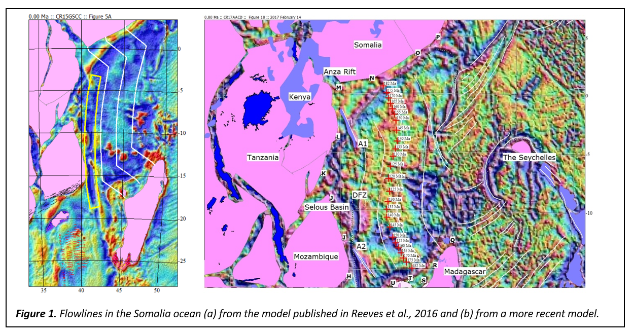
Between Somalia and the Majunga Basin of northern Madagascar, meanwhile, ocean growth was initially almost normal to the margin and the transition from rifting to drifting could occur quite quickly, the growth-direction of the central ridge taking up the gradual change in spreading direction through Jurassic time. A new preferred position for the present (extinct!) ridge (Phethean et al., 2016) is exactly central to such an ocean system and need not have undergone much reorganisation during its post-rift history.
The possibility of a crescent-shaped micro-continent underlying the Comoros archipelago (another abstract submitted by other authors) could be accommodated in this model and would make the separation of the two ‘micro-oceans’ discussed above more complete. Space for such a fragment exists immediately south of the Bur Acaba craton in Somalia if a southeasterly displacement of Somalia during Cretaceous and Cenozoic rifting is accepted. The Comoros fragment would likely originate in an area already stretched and overlain during Karoo rifting and would have achieved its present position with respect to Madagascar by the start of the Cretaceous.
References
De Wit, M.J. & others, 1988. Geological Map of Gondwana reassembled at about 150 Ma. AAPG
Phethean, J.J.J., Kalnins, L.M., van Hunen, J., Biffi, P.G., Davies, R.J. & McCaffrey, J.W., 2016. Madagascar’s escape from Africa: A high-resolution plate reconstruction for the Western Somali Basin and implications for supercontinent dispersal. Geochemistry, Geophysics, Geosystems. 10.1002/2016GC006624
Reeves, C.V., Teasdale, J.P. & Mahanjane, E.S., 2015. Extended abstract, PESGB/GSH London September 2015.
Reeves, C.V., Teasdale, J.P. & Mahanjane, E.S., 2016. Insight into the Eastern Margin of Africa from a new tectonic model of the Indian Ocean. In Nemčok, M., Rybár, S., Sinha, S.T., Hermeston, S.A., and Ledvényiová, L. (eds) Transform margins: Development, Controls and Petroleum systems. Geological Society, London. Special publication 431, pp 299-322.
Sandwell, D.T., Müller, D.R., Smith, W.H.F., Garcia, E. and Francis, R., 2014. New global marine gravity model from CryoSat-2 and Jason-1 reveals buried tectonic structure. Science, 346, pp 65-67.
More detailed research updates and computer animations: