
Buzzard and Verbier
Buzzard, classified as a Giant oilfield, was discovered in 2001 by well 20/06-3Z (OWC). It took until 4q2017, a further 16 years, before Verbier was discovered 20/5b-13Z. How large will the Verbier discovery become?
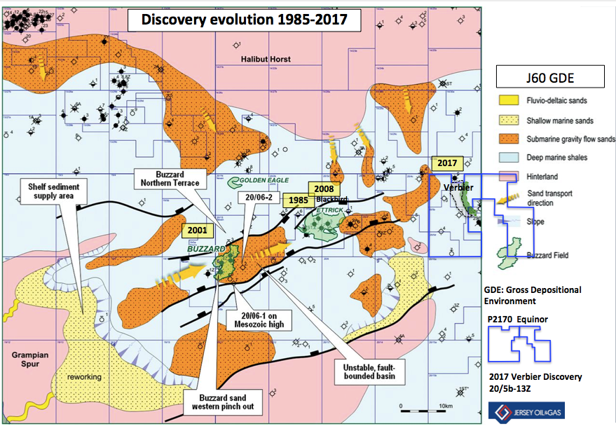
Figure 1. Upper Jurassic Gross Depositional Environment map, Moray Firth Basin
Copyright – Ray et al. 2018, Volume 8, 2018 Petroleum Geology of NW Europe: 50 Years of Learning – Proceedings of the 8th Petroleum Geology Conference
The Petroleum Exploration Society of Great Britain
The Petroleum Exploration Society of Great Britain (PESGB) Charity has many missions, one of which is to actively promote the education of the Earth Sciences and to reach out to the wider public audience. Geology has been and will remain a very exciting prospective career path for school students to consider.
Special Lecture
In support of this objective, the PESGB is staging a Special Lecture. The talk will be on the Buzzard Field in the Moray Firth Basin. Buzzard is the largest producing oil field on the UK Continental Shelf.
The Buzzard Field: Exploration, Appraisal, Phase I Development & Beyond
by Dean Gagnon, Nexen Petroleum U.K. Ltd
It was discovered in 2001, rapidly appraised in 2001-2003 and the field was brought onto Production in 2007. At sanctioning of the Field Development Programme, submitted in 2003, the field was estimated to contain between 757 and 1,224 MMstb original-oil-in-place (OOIP). The current OOIP is now in excess of 1,500 MMstb. ‘Large oil fields get even larger over history’.
Nexen Petroleum UK Limited is the operator of the Field. The field partners are Shell U.K., (BG Group plc), Suncor UK (29.9%)
(Petro-Canada UK Ltd) and Edinburgh Oil and Gas (5%).
The talk will be held on the evening of Tuesday 30 Oct 2018 at 18:00 in London. It will be given at Burlington House, The Geological Society which is located next to the Royal Academy of Arts on Piccadilly Street, Mayfair, London W1J 0BD.
All members of the PESGB are asked to invite friends, students and or school students to the talk through a pre registration process available on the PESGB website.
Buzzard Structure and Trap
The trapping mechanism for the field is exclusively stratigraphic in nature as Buzzard sands are completely enclosed within sealing shale of the Kimmeridge Clay Formation. The field is dip closed to the east by regional dip. And it relied on an up-dip stratigraphic pinch out to the west, north and south. Figure 2.
Within the Buzzard Field development area, the main accumulation is offset by several west – east oriented normal faults (Figure 2). These divide the field into three main regions referred to as the Southern, Central and Northern Panels, flanked by smaller structural terraces. The faults have a maximum offset of about 250 ft and are more or less continuous across the area of the accumulation. Both the Southern-Central and Central-Northern Panel bounding faults throw down to the north. The Northern Panel is limited on its northern margin by a down to the south, west – east oriented normal fault. Beyond this lies the Buzzard Northern Terrace into which the 20/01-5 appraisal well was drilled. Figure 1.
The sands were deposited by turbidite flows, from the west, into a structural low between the southerly Mesozoic high and the Buzzard Northern Terrace (Figure 2). This gave rise to a thick sandy sequence in the centre of the low, pinching-out onto the northern and southern flanks (the sands were not deposited in 20/06-1) and also westwards, towards the shelfal source area. Regional dip down to the east limits the oil accumulation with the field oil – water contact lying west and slightly up-dip of well 20/06-2 (Figure 3).
The Buzzard field has a proven an oil column height of over 1400 ft.
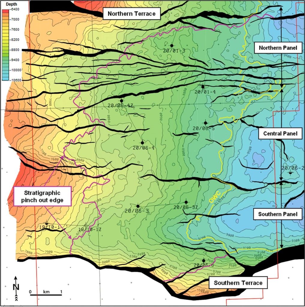
Figure 2. Buzzard Field Top reservoir Depth map, showing structural fault configuration and location of exploration and appraisal wells. Copyright – Ray et al. 2018, Volume 8, 2018 Petroleum Geology of NW Europe: 50 Years of Learning – Proceedings of the 8th Petroleum Geology Conference
Buzzard Reservoir
The Late Kimmeridgian to Early Volgian Buzzard Sandstone Member was deposited during this syn-rift phase into a relatively deep and anoxic basin. Three major phases of turbidite sand deposition are informally recognized within the Kimmeridge Clay Formation: the Buzzard, Ettrick and Burns Sandstone Members, of which Buzzard is the oldest (Ray et al. 2018). The Upper Jurassic interval, is dominated by the Buzzard Sandstone Member and it is overlain by very thin, shale-prone Ettrick and Burns sections.
The FDP reservoir subdivision, originally defined in the discovery well 20/06-3, was both litho-stratigraphic and bio-stratigraphic driven. The reservoir sequence was subdivided into five chrono-stratigraphic constrained packages referred to, from top to bottom, as the Buzzard 4 (B4), Buzzard 3 (B3), Buzzard 2 (B2), Buzzard 1 (B1) and Buzzard 0 (B0) units (Figure 3). The uppermost reservoir unit, B4, was described as a laterally extensive, massive sand unit, dominated by high net-to-gross, high-density turbidite sandstones.
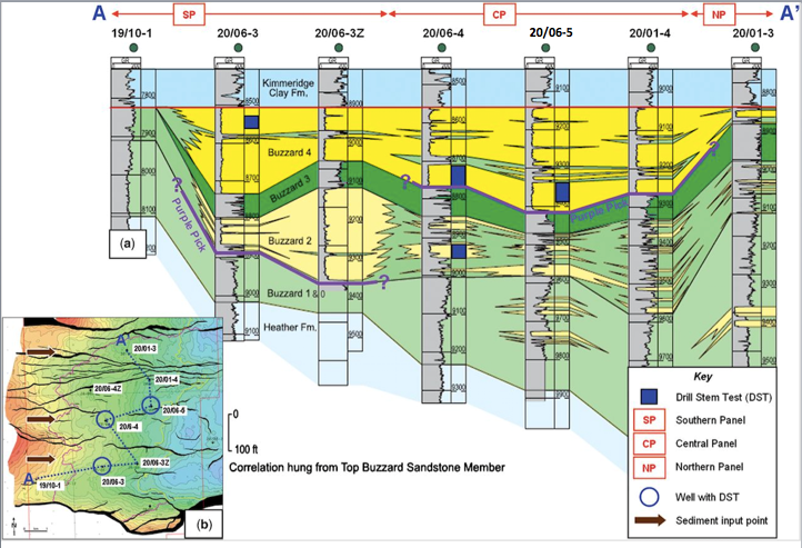
Figure 3. Buzzard Field an appraisal well correlation of the Southern-, Central- and Northern Panels.
Copyright – Ray et al. 2018, Volume 8, 2018 Petroleum Geology of NW Europe: 50 Years of Learning – Proceedings of the 8th Petroleum Geology Conference
A west-east seismic dip section through the discovery well 20/6-3 in the South Panel illustrates the stratigraphic thinning of the Buzzard 4 and specifically the stratigraphic pinch out of the Lower B4 sandstone. Figure 4.
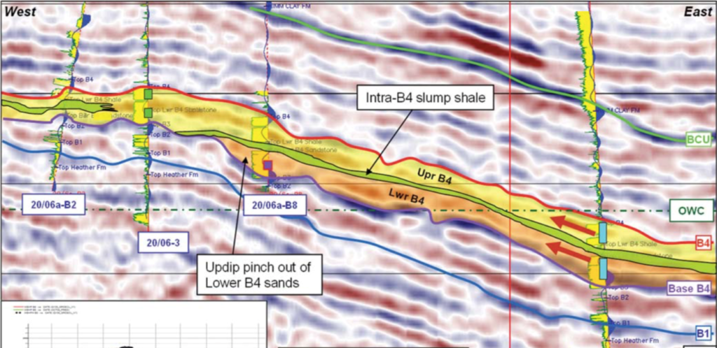
Figure 4. Buzzard Field a West – East seismic section (‘dip’) across the South Panel through the discovery well 20/06-3. Copyright – Ray et al. 2018, Volume 8, 2018 Petroleum Geology of NW Europe: 50 Years of Learning – Proceedings of the 8th Petroleum Geology Conference
A comprehensive detailed account of the reservoir and its dynamic performance during the production period of years 2007 to 2018 will be delivered in the PESGB Special Lecture on Buzzard. The talk will address the current work that underpins the well planning for the forthcoming ‘Infill’ and ‘Buzzard Phase II’ (BPII) drilling campaigns. The field is now interpreted using an Ocean Bottom Node (OBN) baseline survey and through data retrieved from the 1st 4D monitor survey.
https://www.ges-gb.org.uk/events/pesgb-buzzard-lecture/
Verbier
Equinor U.K. (Statoil U.K.) farmed into the Moray Firth Licence P2170 that comprises part blocks 20/5b and 21/1d. Figure 1. Equinor became the operator from the British Independent Jersey Oil and Gas who announced a commercial agreement on exploration costs and on any future development costs.
The Verbier prospect is situated 55 kilometres east northeast of the Buzzard discovery 20/06-3, Figure 1. Whilst Buzzard is located in the ‘Ettrick’ sub-basin, Verbier is located in the ‘North Buchan Trough’. The two sub basins are separated by a structural high of upstanding Caledonian basement and possible Devonian syn-rift with the Scotney High to the immediate south of Verbier. Figure 5.
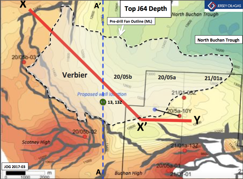
Figure 5 Verbier J64 Fan outline – pre-drill and location of seismic line A-A’
Data sourced from Jersey Oil and Gas Media Presentation 2017-03
Statoil U.K. Press Release – 9 October 2018
https://www.equinor.com/en/news/oil-discovery-verbier-sidetrack-uk.html
The Verbier discovery was made using pre-Broadband 3D data. Figure 6.
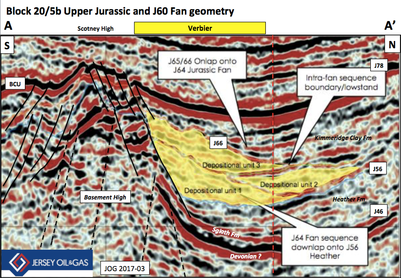
Figure 6. Seismic section A-A’ across the Verbier prospect (pre drill 20/5b-13 and -13Z discovery)
Data sourced from Jersey Oil and Gas Media Presentation 2017-03
The Verbier gross recoverable oil resources are estimated to range between 25 and 130MMstb (Jersey Oil and Gas). This wide range in resources reflects the current uncertainty in the reservoir mapping, the nature of the sandstone geobodies and particularly the net to gross and the resultant net pay.
The Verbier partners in part blocks 20/1b and 21/5d are
- Statoil 70%
- Jersey Oil and Gas U.K. 18%
- CIECO V&C (UK) 12%
2018 Broadband Data
Equinor contracted PGS to shoot new Broadband 3D data in 2Q2018 across Verbier. The data was acquired by PGS vessel Sanco Swift as part of a larger Multi-client 3D survey. The decision to improve the seismic data is undoubtedly to help the geoscientist to interpret the basin infill of the Upper Jurassic. More accurate identification of sequence boundaries and the recognition and mapping of individual sandstone reservoir geobodies, variably bounded by potential intra reservoir mudstone units that act as dynamic barriers, as was found in the case of Buzzard, (not forgetting the Miller and Magnus Field intra reservoir barriers), is the subsurface goal of the interpreter.
Broadband data will significantly help the subsurface team to mitigate reservoir presence risk in Verbier. In turn this will allow a more accurate STOOIP and Reserves to be estimated. It will help the operator to define the criteria for choosing the optimal location for the appraisal well location(s). The fast track volume is estimated to be available in December 2018. Equinor is now planning to appraise Verbier in the 2Q2019 after the interpretation of this new data.

Figure 7. PGS Seismic vessel Sanco Swift
UKCS – Maturing prospectivity and discoveries
The advances made in the acquisition and processing of Geophysical data is today allowing oil companies and their geoscience teams to be much more predictive before drilling exploration wells on the U.K. Continental Shelf (UKCS). And through the interpretation of these new Broadband seismic data sets, it is expected more yet to find oil reserves will be discovered in mature areas and in frontier areas on the UKCS.
It is worthy to point out, that seismic companies TGS and CGG are each shooting new state of the art Broadband surveys in the West of Shetlands. These new data sets will be essential to the oil company exploration teams so as to mature prospectivity after the 31st Round blocks is closed and licences are awarded in 2019 by the OGA. The 31st Round Applications will be accepted by the OGA up to 14.00 on the 7th November 2018.
https://www.ogauthority.co.uk/licensing-consents/licensing-rounds/
OGA Area Development Plan
The OGA regulatory body announced a new Area Development Plan named the Greater Buchan Area (GBA).
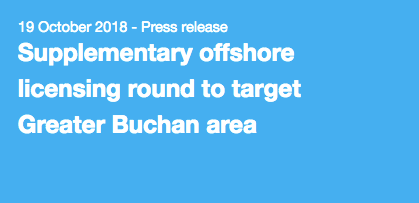
The Oil and Gas Authority (OGA) has initiated a new Area Plan to maximise economic recovery (MER) from the Greater Buchan area of the North Sea, and is asking oil and gas operators to work together to develop the 150-300 million barrels of oil equivalent (mmboe) estimated to be present in the area.
The Greater Buchan area is situated in the Outer Moray Firth, features considerable open, currently unlicensed acreage, including a number of undeveloped discoveries. To maximise recovery of the significant potential recoverable resources in the area, the OGA will open a Supplementary Licensing Round in Q1 2019. It will be supported by newly available data.
The OGA is encouraging companies to partner with each other and collaborate to progress exploration and new developments in the area.
In advance of the round, the OGA will be hosting an information session in Aberdeen for interested oil and gas companies on 15 November 2018. At the event, the OGA will provide an overview on the timing and process of the Supplementary Licence Round and give further details on the supporting information that will be made available.
Area Plans are a shared view amongst North Sea industry participants of the optimal way to achieve MER UK in a specific set of circumstances.
Geology is an exciting career
Petroleum geoscientist’s are encouraged to promote the PESGB Special Lecture by Nexen Petroleum U.K. And thereby promote Geology and Geophysics as an exciting career to school sixth form students and to undergraduates who are reading and studying these subjects at University. Pre-registration of guests is through the PESGB website.
John Wood PESGB 2018-10-19
Reference
The Buzzard figures in this blog, are sourced from the paper: The Buzzard Field: anatomy of the reservoir from appraisal to production, F. M. Ray, S. J. Pinnock, H. Katamish and J. B. Turnbull, Volume 8, 2018 Petroleum Geology of NW Europe: 50 Years of Learning – Proceedings of the 8th Petroleum Geology Conference
The Verbier figures are sourced from the Jersey Oil and Gas Media Presentations.