
Does field-based training still have a role to play in the digital age?
Article by Dean Baker
The study and application of geosciences, as well as other disciplines within the oil and gas industry, has progressed rapidly due to enormous technological advances over the last few decades. High quality seismic imaging and advanced processing are now commonplace; geological modelling packages have become so advanced that a 3D geological model can be generated within a matter of hours as oppose to days or weeks; and the use of Unmanned Aerial Vehicles (UAV) (otherwise known as drones) and high definition digital imagery provide a whole range of possible commercial and training applications for geoscientists in the oil and gas industry. With so much technology at our fingertips, is there still a role for field geology in an increasingly digitally focussed industry?
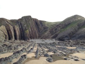
Personally, I have many fond memories of geology fieldtrips during my undergraduate degree, not just for the camaraderie and sangria, but for their value in bringing to life concepts, ideas and theories from lectures or literature based study. In my professional career I have always continued to partake in field based training. From observing the scale and variability of shallow marine, deltaic and fluvial successions of the Book Cliffs in Utah to wonderful examples of structural deformation and folding in Bude, Cornwall, and everything in between, I have always found that I learn new concepts or ideas that can be applied to my work.
Typically as geoscientists we analyse a wide variety of data at numerous scales and try to piece this together to generate an interpretation or model of the subsurface. This data can include 3D seismic which can represent a scale of resolution from tens of metres vertically to kilometres horizontally; to wireline logs and whole core samples representing horizontal and vertical resolution of a few centimetres to tens of centimetres; to core plugs, cuttings and thin sections representing vertical and a horizontal resolution of millimetres to microns.
This spectrum of data gives the geoscientist a perception of horizontal and vertical scale ranging from regional to microscopic, but there is a clear gap, in the order of tens of centimetres to tens of metres, between well logs / whole core samples and 3D seismic. This scale gap is an important one when you consider that this is typically the scale at which reservoir models are built. Understanding and being able to replicate geological features at this scale is often imperative to building a successful geological model and subsequent dynamic simulation for both reservoir development planning and production monitoring. This not only relates to facies geometry and interrelationships but also to structural features and their dynamic behaviour, in particular faults. I may be biased as a geologist with a background in reservoir geology and geomodelling, but in my view the value of field training transcends into other disciplines such as geophysics, reservoir engineering and petrophysics.
For example, geophysicists are using ever more advanced inversion products to extract information from seismic data, and at some point the interpreter needs to ‘ground truth’ their interpretation; Is this geobody extraction a realistic representation of the geometry of the depositional system or a data artefact? Does the interpreted fault pattern make geological sense or is the data over-interpreted? Field examples and field analogues can help provide a reality check for interpreters which can sometimes be lost when using ‘push-button’ interpretation software. For reservoir engineers, viewing field examples of how facies can vary and how faults look and behave in three dimensions can be useful for better understanding flow units and barriers within dynamic reservoir simulation models. And for petrophysicists, field training might bring what is so often a one-dimensional interpretation of a well log into three-dimensional space, e.g. an appreciation of how porosity, permeability and net to gross vary laterally in relation to vertically. This can aid the petrophysicist’s understanding of how petrophysical properties vary on a multi-well field scale reservoir study.
If one can accept that field training and study still has some advantages, what then are the potential drawbacks? Possible disadvantages could be:
- Time – typically field trips will last several days and may involve travel to remote areas;
- Safety – traversing rocky outcrops, standing under cliff sections, timing of tides and safely viewing outcrops along busy road cuttings does not come without health and safety risks;
- Cost – An increasingly important factor in the current climate is cost. Field trips are generally quite expensive and with training budgets cut can companies still afford to pay for field-based training?
So are there alternatives to field based training that can fill the data resolution gap? One possible alternative is to use case studies and analogues from literature. This resource, when combined with physical data, can be valuable for characterising reservoir properties and predicting reservoir performance. Other alternatives, more aligned to the digital age, are high definition outcrop photos and videos and digital outcrop models. UAVs (or drones) are being increasingly used to view previously inaccessible outcrops and/or provide a unique perspective of the geology in outcrop sections. Clearly there are huge advantages in the use of digital technology in training, particularly when combined with existing classroom materials to provide an interactive training experience. The use of 3D digital outcrop models in combination with traditional hand samples, digital well logs and regional maps can give a multi-faceted experience that can enhance learning for geoscientists and engineers.
The aforementioned uses for digital technology in training can go some way towards providing the all-important perspective that is required for true understanding of scale and variability in depositional sequences or structural features. However, along with literature-based case studies, in my opinion, they are not a replacement for field-based study. Only in the field can you truly gain perspective of variation at a granular to metric or even kilometric scale at the same time. Only at the rock face can you walk between different depositional facies such as fluvial channel, overbank and floodplain and view the textural and geometrical differences in detail. Only in the field can you view the stratigraphy within a faulted sequence and observe the interaction of sediments within the fault plane and relate this to sealing potential. Only when standing in front of the outcrop can you get the true perspective of variation in geometry and scale between different depositional facies and relate this back to seismic scale resolution.
Recent advances in technology have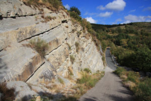 added significantly to our ability to capture and process geological information and increase our learning potential using a variety of sources. Some may argue that this largely negates the need for field-based study. However, in my view some advances in technology have now increased the necessity for field-based training to provide a reality check for our increasingly computer model driven interpretations of the subsurface. In addition, there is no substitute for viewing geology first hand rather than through a computer monitor or television screen. In the same way that seeing a historical monument or sporting event in a photograph or video is not the same as seeing the real thing, the same can be said for outcrops in the field and digital outcrop models. Above all else, in a world dominated by social media and increasing interaction with digital technology, it’s nice every now and again to interact with other subsurface professionals in the field, at the rock face, discussing technical problems and sharing knowledge. I therefore believe wholeheartedly that there is still a place for field-based study in the digital age, despite the relatively high cost, and I encourage all geoscientists and engineers alike to embrace the many benefits as well as the fresh air!