William Smith's 'Strata Identified'
Article by Peter Wigley
The geological pioneer William Smith is best known for his ground breaking geological map of England and Wales (with parts of Scotland) which was first published in 1815. Less well known is his unfinished publication, Strata Identified by Organized Fossils (1816-19).
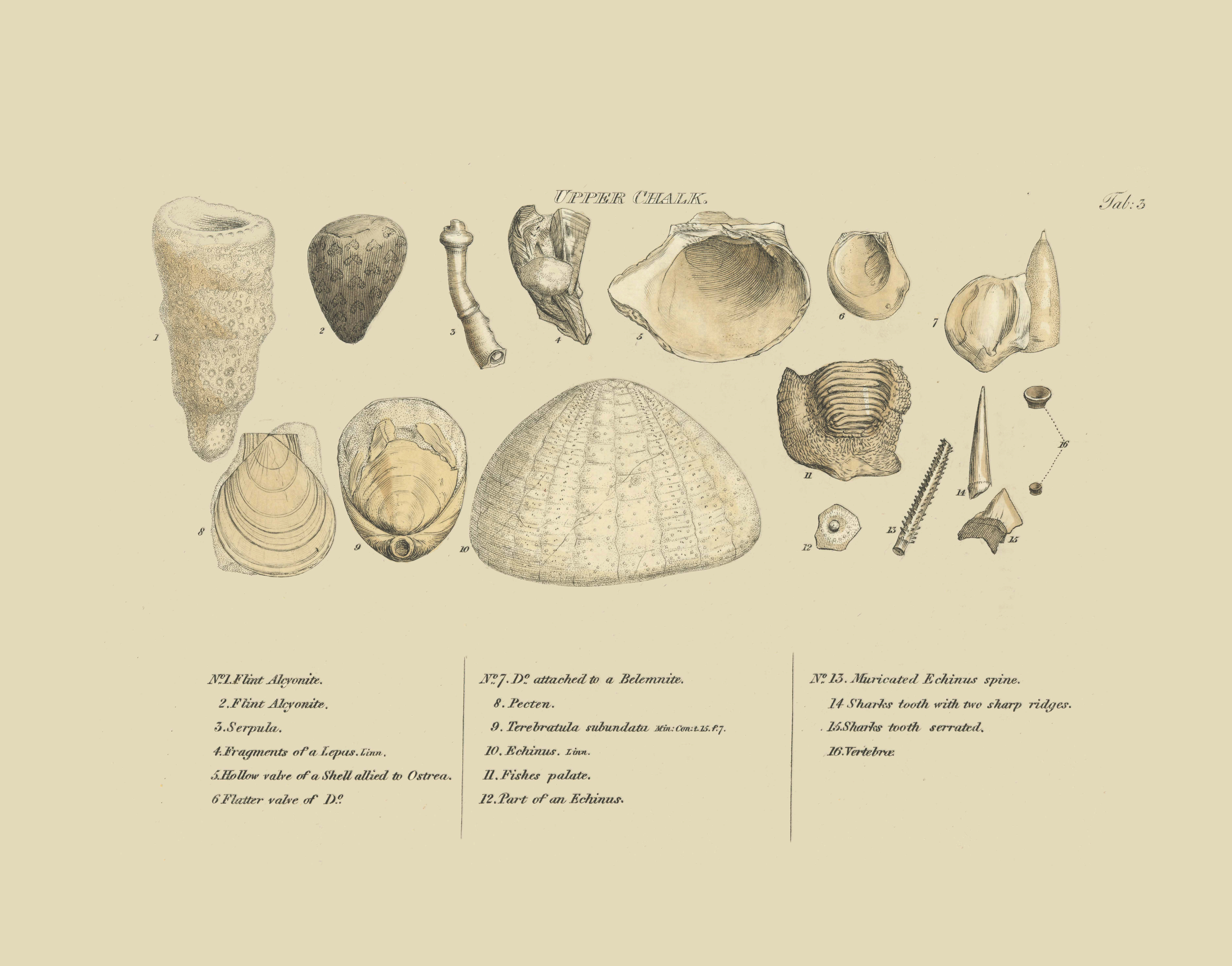
Strata Identified was published in four parts between 1816 and 1819 and contains 18 beautifully illustrated plates (engraved by James Sowerby) showing characteristic fossils, in stratigraphic order, from the London Clay and Crag down to the Fullers Earth. Accompanying each plate is a description of the strata associated with the fossils and further information on soils, drainage and topography. An example of one of the plates from the Upper Chalk is illustrated in this blog. It is interesting to note that Smith used different coloured paper for each of the plates. Many of these colours correspond to the colours of strata he used on his geological maps.
In his introduction Smith stressed the importance of his stratigraphic method to agriculture, since underlying strata often influence the soil type, quality and drainage. He also made a clear distinction between those well preserved fossils found in situ and abraded fossils (which he called alluvial) considered by him to have been eroded from strata by the action of water. While he did not discount that the alluvial fossils may be associated with the biblical flood he did not believe that the fossils contained within strata were diluvial. Smith proposed to discuss his alluvial fossils in a separate part of the publication but this was never completed, however, in the frontispiece he shows a wonderful alluvial fossil tooth of “some extinct monstrous unknown animal “, probably a mammoth. Also uncompleted were other plates and descriptions for older strata beneath the Fullers Earth Rock, however draft copies of plates for the Lias and Carboniferous do exist in the Smith archive at the Oxford University Museum of Natural History.
Smith identified each of his illustrated fossils and also gave location information. Recently, with the help of Hugh Torrens, I have been able to locate most of Smith’s localities and show them on Google Earth. The downloadable Google Earth KMZ file (Smith fossils and locations) shows 172 different locations with over 400 characteristic fossils. Although many locations list a single fossil, many locations list several fossils (up to as many as 12 fossils at one location). In order to display individual fossils each illustration has been extracted from the original plate and stored on a Cloud Server. A click on a place marker on the map will display information about the fossil and associated metadata and also a link to the illustration on the Cloud Server.
A facsimile of Strata Identified has been completed and it is hoped to publish this together with an introduction by Hugh Torrens and location maps later this year.
Smith also published Stratigraphical System of Organized Fossils (1817), in this work (also unfinished) he catalogued some 700 species from over 2,500 specimens which he was forced to sell to the British Museum in order to pay off some of his debtors. Smith was keen for the British Museum to publically display his collection but the museum showed a high degree of disinterest and failed to appreciate Smith’s stratigraphic arrangement of the fossils.